Siler City, NC
DOWNLOAD PDFHow Siler City, NC, Integrated Healthy Food Access into Pedestrian Planning
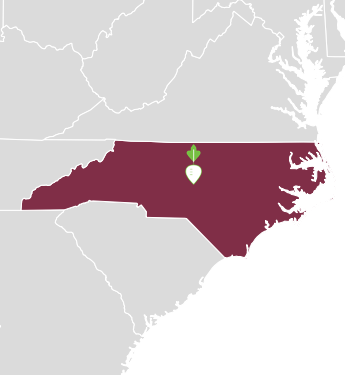
Siler City is a small town in the western part of Chatham County, located in the middle of North Carolina. Its commerce is based on agriculture and industry, such as textiles, furniture, hosiery and food processing, and in recent years, the town has experienced factory and poultry plant closings and related economic issues.1 The town has one of the highest percentages of Hispanic residents in the state. In 2013, approximately half of Siler City’s 7,972 residents were of Hispanic/Latino ethnicity/origin (compared to 8.4 percent statewide).2 More than a quarter of the population lives below the poverty line and many residents do not own motor vehicles.3 In addition, the city offers few public transit options and lacks many safe pedestrian routes to grocery stores and related vendors. As a result, Siler City residents have limited access to healthy food options.4
The Problem
Numerous studies have shown that low-income and predominantly racial/ethnic minority communities are disproportionately exposed to food deserts, such as those in Siler City.5
Health disparities in food access are linked to poor dietary patterns and unhealthy weight, which are established risk factors for diabetes, heart disease and other nutrition-related diseases.6 Indeed, higher than average disparities in terms of health outcomes are evident in Siler City, given the high concentration of low-income residents with limited access to healthy food options, according to Chatham County Public Health Department’s Mike Zelek.7 The prevalence of unhealthy weight is a top health concern in Siler City, as it is in both Chatham County and the state of North Carolina.8
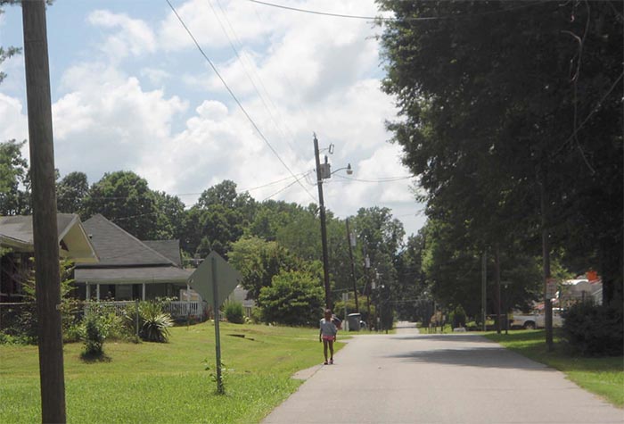
Many Siler City residents, particularly those who live in and around the downtown area, rely on walking as the main way to reach local groceries and other food vendors. However, limitations in the town’s infrastructure presents pedestrians with challenges as they walk to grocery stores:
- Roadways act as barriers; 9
- High priority locations have sidewalk gaps;
- Several sidewalks are deteriorating or blocked by obstructions, such as vegetation or utilities;
- Many roadways lack shade and pedestrian lighting;
- Intersections often lack ADA-accessible facilities, such as curb ramps; and
- The city lacks safe connections between neighborhood areas, recreation areas, and healthy food opportunities.10
| Key Demographics | |
|---|---|
| Population: 1 | 8,444 |
| Land Area (in sq. mi): | 6 |
| Race/Ethnicity: 2 | 44%-White 19.1%-Black or African American 0.4%-Asian 49.6%-Hispanic/Latino (of any race) |
| Population by Age: 2 | 29.8%-under 18 years 58.1%-18-64 years 12.1%-65 year and older |
| Education: 3 | 66%-High school graduate or higher 11.6%-Bachelor’s degree or higher |
| Median Household Income: 3 | $29,956 |
| Population in Poverty: 3 | 26.3% (compared to 17.4% statewide and 15.8% in the U.S. as a whole) |
| Low Income and Low Food Access: 4 | 100% of census tracts (2 tracts) |
Because these infrastructure challenges in Siler City affect both land use and public health, Siler City and Chatham County saw an opportunity in 2013 to integrate healthy food access into pedestrian planning. This approach enabled the town to devise strategies to improve its infrastructure for pedestrians and at the same time to ensure that residents were provided safe and convenient access to healthy food opportunities.
The Policy Solution
A Pedestrian Master Plan.
The Town of Siler City’s innovative linkage of public health with urban design draws on past land use and transportation planning, combined with new health-related research and analysis, as well as input and support from a variety of local and regional partners.
Collaborative Funding
In June 2010, Siler City was accepted into North Carolina’s Small Town Economic Prosperity (STEP) program. This program works with rural municipalities to stimulate economic growth in areas with low to moderate incomes and communities with limited resources. The STEP Community Leadership Team developed a long-term strategic plan for Siler City that focused specifically on providing incentives to spur economic development to improve the standard of living and quality of life for the town’s residents.11
As a result of additional support and funding from local, regional and national partners, the town decided to incorporate local health-related data and analysis into the Pedestrian Master Plan that it was just beginning to develop.12 The goal of the town’s Pedestrian Master Plan then became to improve Siler City’s infrastructure for pedestrians and to foster a “walking culture” through related programs and policies that support pedestrian transportation and safety, as well as healthy eating and active lifestyles.13
Siler City Pedestrian Master Plan
Timeline of Events
2010
JUNE: Siler City accepted into North Carolina’s Small Town Economic Prosperity (STEP) program
2012
Siler City awarded a matching grant from North Carolina Department of Transportation Bicycle and Pedestrian Planning Grant Program14
North Carolina awarded funding from a Centers for Disease Control and Prevention Community Transformation Grant (CTG).15 Funding from this grant was used to support local initiatives, including in Chatham County through the Chatham County Public Health Department
Siler City receives a portion of CTG program funding to supplement the state’s Department of Transportation’s Bicycle and Pedestrian Grant funding.
2013
MARCH: Steering Committee launches project website in English and Spanish
SPRING/SUMMER: Neighborhood walkability assessments and healthy food vendor assessments conducted; stakeholder and community meetings held; public workshops and events solicit community input; final plan drafted
SEPTEMBER: Steering Committee approves final Pedestrian Master Plan
OCTOBER: North Carolina Department of Transportation approves plan
NOVEMBER: Siler City’s Board of Commissioners approves plan
2022
Anticipated completion date of Pedestrian Master Plan project
Policy Development Process: Background Work
Healthy Foods Assessment
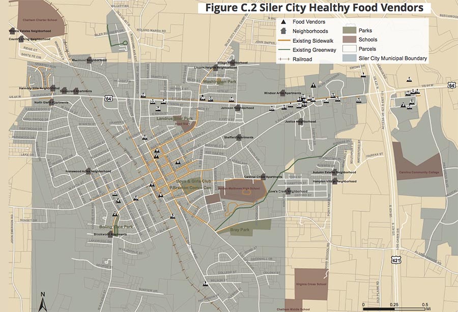
In mid-2013, Siler City hired two University of North Carolina at Chapel Hill graduate students in the Department of Health Behavior to conduct an inventory of all 82 Chatham County food vendors, including corner stores, grocery stores, supermarkets, gas stations, tiendas,16 dollar stores, farmers’ markets, pharmacies, and roadside stands, including the 45 food vendors in Siler City. The evaluators mapped the locations of each food vendor and then developed a survey instrument. This assessment of the current availability of local healthy food options within the town became part of the background research for Siler City’s Pedestrian Master Plan.
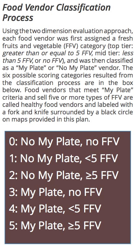
The Healthy Foods Assessment, based on the Nutrition Environmental Measures Survey and the Food Retail Outlet Survey Tool, used two criteria to categorize vendors:
- Fresh fruits and vegetables available at each vendor, based on three categories (None, 1-4 types, 5 or more types). The U.S. Department of Agriculture (USDA) recommends that adults consume five or more fresh fruits and vegetables daily; thus, vendors that offered at least five fruit and vegetables were designated as “top tier” healthy food vendors.
- Availability of ingredients necessary to create a MyPlate meal. A store had to sell at least one food item from all five food groups (fruits, vegetables, grains, protein, and dairy) to achieve “My Plate” status.17 Vendors were categorized as either “Fulfills MyPlate” or “Does not fulfill MyPlate.”
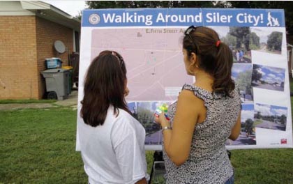
Neighborhood Walkability Assessment
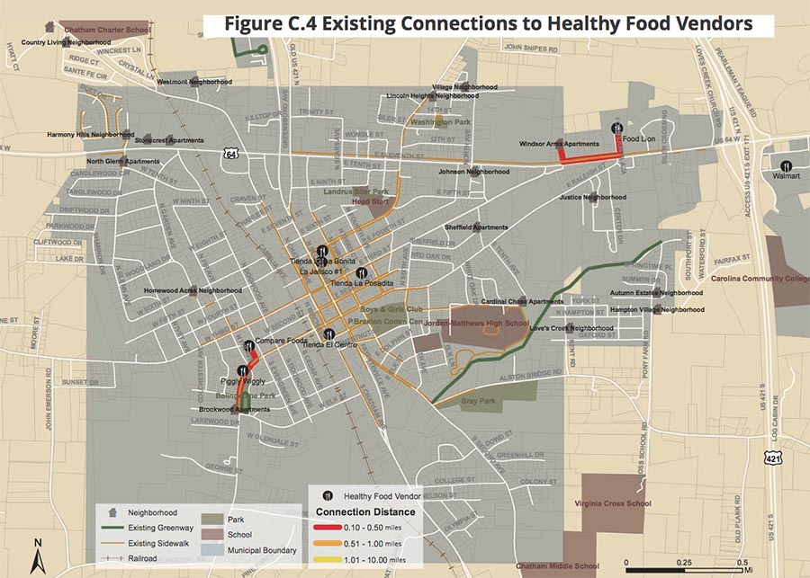
As part of the background research, the consultant team also conducted on-the-ground field research, including an inventory of intersections, a photographic survey, and an exploration of neighborhoods, schools, parks, existing trails, and the downtown core of Siler City – all to identify opportunities for connections between neighbors, key destinations, recreation areas, and food vendors.
Neighborhood Food Access Assessment
In addition, city planners and the project consultant team18 analyzed neighborhood access to healthy food vendors and recreation areas based on the existing pedestrian network of sidewalks and crossings. Their analysis showed that the lack of safe routes, linkages, and crossings significantly inhibited residents from accessing healthy food selections.19 In fact, only two of 21 neighborhoods in Siler City had pedestrian access to a healthy food vendor.20
Policy Development Process: Planning
Website Launch
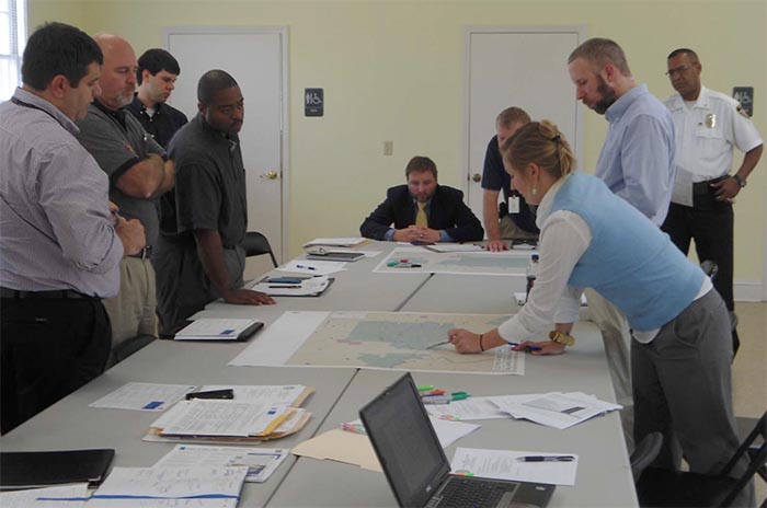
Siler City’s Steering Committee for the Pedestrian Master Plan did extensive public outreach and engagement during the planning phase to ensure that this was a community-driven collaborative process and that a variety of local perspectives were solicited, considered, and incorporated into the plan. The makeup of the Steering Committee reflected this emphasis on broad participation. Members included local staff, employees from the state Department of Transportation and the Triangle Area Regional Planning Organization,21 interested residents, and key stakeholders, such as representatives from public health and the school system.22 In March 2013, after a kick-off meeting, the Steering Committee launched a project website which was largely in English, but which included a section in Spanish that described the pedestrian plan, planning process, project comment form, project information card, and upcoming event dates.
Public Outreach & Community Engagement
More than 300 local residents participated in the planning process through comment forms, public workshops, and meetings. Throughout the process, Steering Committee members held meetings with local Hispanic groups, business owners, neighborhood leaders, and other residents. A targeted public outreach strategy included face-to-face meetings, letters, emails, and phone calls to various sectors in Siler City, such as schools, merchants, nonprofit organizations, the Chamber of Commerce, and the faith community.
Public events, such as the May 4, 2013 5K Race for Family Peace, held in downtown Siler City, and the August 6, 2013 National Night Out celebration, were used as opportunities to share information about the plan and to invite questions and comments from the public about desired neighborhood improvements. Public comment forms in both English and Spanish were circulated widely in both hard copy and online versions. Over 150 responses to the public comment request were collected. In addition, stakeholder meetings with representatives from the community, including business owners, as well as public workshops in three different neighborhood locations, helped the town gain insight on how local stakeholders prioritized different pedestrian plan criteria, including “Direct access to healthy food opportunities.” 23
Policy Plan
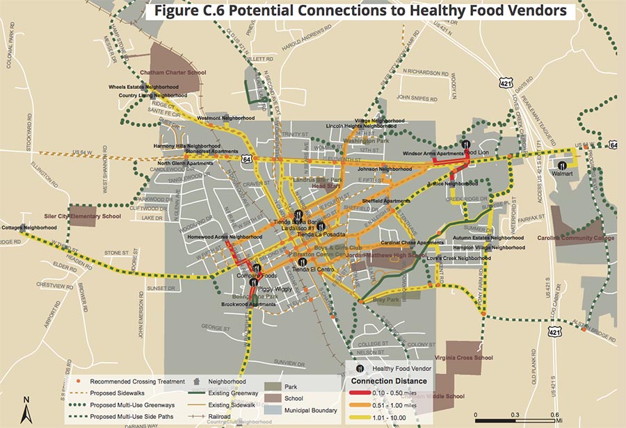
After analyzing the poor connections between neighborhood areas, recreation areas, and healthy food options, and taking into account the valuable community input, the Town developed a master pedestrian plan that addressed the issue of inadequate routes, linkages and crossings to recreation areas, as well as to healthy food vendors. The master plan links all 21 Siler City neighborhoods with each of the nine grocery stores classified as “top tier.” It also increases the number of complete connections between healthy food vendors and neighborhoods from six (6) to 189. Of these 189 connections, 5 are less than half a mile in length, while another 24 are less than a mile in length.24
The Steering Committee approved the final plan on September 17, 2013. The Department of Transportation then approved it on October 21, 2013, and the town’s Board of Commissioners approved it on November 4, 2013. Siler City’s Pedestrian Master Plan project is now on a multi-phase track, and much of the work in the downtown area, with redesigned sidewalks, crosswalks, curb ramps, greenway trails, and other amenities, is expected to be completed by 2022. The sequence of immediate tasks include design, purchase of right-of-ways, and construction.25 No significant implementation issues have arisen to date.
Anticipated Impact
The improved infrastructure of Siler City will make it safer and easier to walk throughout the town and will give Siler City pedestrians significantly greater access to stores that provide healthy foods. In addition, this new “walkable community” will reduce health disparities among a population with an increased risk of poor health outcomes by improving healthy food access in a way that includes both physical activity and nutrition. The new infrastructure will also benefit the local economy by increasing property values; enhance resident quality of life by providing access to quality recreational opportunities such as parks, trails, and bicycle routes; and improve the environment by increasing multi-use greenways and open space corridors.26
In addition to the pedestrian project now underway, the integrated planning and public health approach spearheaded in Siler City has resulted in several other long-term partnerships, including Health Department staff representation on local planning advisory committees, gap analyses of regional bike routes, and potential Health Impact Assessment collaborations. What’s more, the planning and health departments continue to partner on the Chatham Health Alliance and reach out to each other on other projects involving priority health issues.
Lessons Learned
- Well-thought out comprehensive community planning can play a key role in addressing social and health equity.
- Community planners are also public health practitioners.
- To obtain broad population-level health impact, public health should reach out to professionals in other fields, including the built environment, and engage new partners like planners and town managers to create policy changes.
- Partnerships between community planners and public health can be strategic and fiscally innovative ways to integrate health into a social ecological framework. Collaboration between these areas and among all involved parties can lay groundwork for future policy opportunities.
- In addition to national, regional, and local partners and experts, over 300 local residents participated in the process to develop Siler City’s Pedestrian Master Plan. Promoting and enabling open and active participation by communities in the form of comments, public workshops and meetings, can help ensure local buy-in, support, and pride.
About the Healthy Food Policy Project (HFPP)
The HFPP identifies and elevates local laws that seek to promote access to healthy food while also contributing to strong local economies, an improved environment, and health equity, with a focus on socially disadvantaged and marginalized groups. HFPP is a multiyear collaboration of the Center for Agriculture and Food Systems at Vermont Law School, the Public Health Law Center at Mitchell Hamline School of Law, and the Rudd Center for Food Policy & Obesity at the University of Connecticut. This project is funded by the National Agricultural Library, Agricultural Research Service, U.S. Department of Agriculture.
Additional Acknowledgments
This case study relies heavily on information provided during interviews and subsequent communications with Mike Zelek, Health Promotion and Policy Division Director, Chatham County Public Health Dep’t (July 19, 2017) and Jack Meadows, Director of Planning and Community Development, Siler City (July 25, 2017). The Healthy Food Policy Project (HFPP) collaborators thank these individuals for their contributions. We have not included citations to the information they have contributed throughout the body of this case study, but have relied upon it unless another source is indicated. Siler City maps and photos are included, courtesy of the Town of Siler City, and are all found in the Siler City, NC, Pedestrian Master Plan (2013).
The HFPP also thanks its Advisory Committee members for their guidance and feedback throughout the project. Advisory Committee members are: Dr. David Procter with the Rural Grocery Initiative at Kansas State University, Dr. Samina Raja with Growing Food Connections at the University of Buffalo, and Kathryn Lynch Underwood with the Detroit City Planning Commission. Previous advisory committee members include Pakou Hang with the Hmong American Farmers Association and Emily Broad Leib with the Harvard Food Law and Policy Clinic. Renee Gross, JD, served as a project consultant from 2015-2018.
Notes
1 Telephone interview with Mike Zelek, Health Promotion and Policy Division Director, Chatham County Public Health Dep’t (July 19, 2017).
2 Based on demographic estimates used in the Town of Siler City, Downtown Master Plan Report (Mar. 8, 2013) and the Siler City, NC Pedestrian Master Plan (2013) See U.S. Census Bureau, QuickFacts: Siler City town, North Carolina (2010), https://www.census.gov/quickfacts/fact/table/silercitytownnorthcarolina/RHI725216. See also Paul Cuadros, U. of North Carolina, The Courage to Lead: Scholar-Activism and Health Equity in Turbulent Times (Sept. 29, 2017) webcast (describing health disparities among Latino community in Siler City), https://sph.unc.edu/sph-webcast/2017-09-29_nherw.
3 U.S. Census Bureau, 2011-2015 American Community Survey 5-Year Estimates. See also U.S. Dep’t Agriculture, Economic Research Service, Food Access Research Atlas, https://www.ers.usda.gov/data-products/food-access-research-atlas/go-to-the-atlas; Siler City, NC Pedestrian Master Plan, 1-1 (2013); Town of Siler City, Downtown Master Plan Report (Mar. 8, 2013), http://www.silercity.org/vertical/sites/%7B3856B9B8-1C42-483B-A4CB-C0D6B1FE7142%7D/uploads/SC-Downtown_Master_Plan_report_3.8.13.pdf.
4 Town of Siler City, Downtown Master Plan Report (Mar. 8, 2013), http://www.silercity.org/vertical/sites/%7B3856B9B8-1C42-483B-A4CB-C0D6B1FE7142%7D/uploads/SC-Downtown_Master_Plan_report_3.8.13.pdf.
5 See, e.g., Nicole Larson et al., Neighborhood Environments: Disparities in Access to Healthy Foods in the U.S., 36 Am. J. Prev. Med. (2009) 74-81, https://www.ncbi.nlm.nih.gov/pmc/articles/PMC3482049; Joseph Sharkey et al., Neighborhood Deprivation, Vehicle Ownership, and Potential Spatial Access to a Variety of Fruits and Vegetables in a Large Rural Area in Texas, 9 International J. Health Geographics (2010) 26, https://www.ncbi.nlm.nih.gov/pmc/articles/PMC2881903.
6 Larson, supra note 5.
7 See telephone interview with Mike Zelek, Health Promotion and Policy Division Director, Chatham County Public Health Dep’t (July 19, 2017).
8 Mike Zelek, Linking Public Health and Planning: Siler City Pedestrian Master Plan (presentation for NCAMPO Conference) (2014).
9 U.S. Highway 64, for example, travels through the northern section of Siler City.
10 Siler City, NC Pedestrian Master Plan 2-18 (2013), http://www.silercity.org/index.asp?SEC=1CB30A61-8F90-4209-BF0D-CBC0F3F65187&Type=B_BASIC.
11 Town of Siler City, Downtown Master Plan Report 2-5 (Mar. 8, 2013), http://www.silercity.org/vertical/sites/%7B3856B9B8-1C42-483B-A4CB-C0D6B1FE7142%7D/uploads/SC-Downtown_Master_Plan_report_3.8.13.pdf.
12 Siler City, NC Pedestrian Master Plan 1-1 (2013).
13 Id. at 1-2.
14 Siler City, NC Pedestrian Master Plan 1-1 (2013). The grant’s purpose was to encourage municipalities “to develop comprehensive bicycle plans and pedestrian plans
15 Mike Zelek, Integrating Healthy Food Access into Pedestrian Planning (presentation for APHA conference) (2014). These grants are part of CDC’s effort to support communities in implementing broad, sustainable strategies to reduce health disparities and promote health. At this time, CTG grants funded over 40 comprehensive and allied community density and policy level plans across the U.S., all of which incorporated health in some way. The grants, for example, enabled the development of food policy councils, supported tobacco control policies, and promoted health local foods.) See, e.g., CDC, Division of Community Health: Making Healthy Living Easier, Community Transportation Grants 2011-2014 (last accessed Sept. 2017), https://www.cdc.gov/nccdphp/dch/programs/communitytransformation/index.htm.
16 A “tienda” is a booth or shop where food is sold.
17 Siler City, NC Pedestrian Master Plan 2-21 (2013).
18 Project consultants included the landscape architecture and land planning team of Alta/Greenways and Coaly Design.
19 Siler City, NC Pedestrian Master Plan C-10 (2013).
20 Id. at 2-24.
21 The Triangle Area Regional Planning Organization (TARPO) is a voluntary association of local governments in Chatham, Lee, Moore, and Orange Counties that plans rural transportation systems and advises the North Carolina Department of Transportation on rural transportation policy.
22 Siler City, NC Pedestrian Master Plan 1-2 (2013).
23 According to the survey, of the 18 pedestrian plan criteria, “Direct access to healthy food options” was roughly in the middle.
24 Siler City, NC Pedestrian Master Plan 1-1 (2013).
25 Telephone interview with Jack Meadows, Director of Planning and Community Development, Siler City (July 25, 2017).
26 Siler City, NC Pedestrian Master Plan 1-5 (2013).
Key Demographics Table Notes
1 Source: Vintage 2016 Population Estimates: Population Estimates
2 Source: 2010 U.S. Census Bureau, Quick Facts
3 Source: 2011-2015 American Community Survey 5-Year Profiles
4 Source: 2015 USDA/ERS Food Access Data